Red Zone Futures: Cultural, Archaeology and Heritage

Mana Whenua / Ngāi Tahu Cultural History
“Ōtautahi | Christchurch lies within the Takiwā of Ngāi Tūāhuriri who exercise Rangatiratanga and Kaitiakitanga over the wider Christchurch area.
Ōtautahi is of high significance to Ngāi Tūāhuriri and also Ngāi Tahu whānui due to historical occupation, use of natural resources and numerous occupations to sites of significance.
Traditionally Ōtautahi was used for Mahinga Kai, trade, occupation and transport. The historical and current values within the residential red zone and wider areas are based predominantly on Mahinga Kai, Wāhi Taonga and Wāhi Tapu.”

Archaeology and Heritage
The Replacement Christchurch District Plan identifies historic heritage places and settings which represent cultural and historic themes and activities of importance to the district. Significant historic heritage places with a high degree of authenticity and integrity are listed on a schedule and are subject to rules or provisions that protect them from inappropriate subdivision, use and development.
Archsite is the national inventory of archaeological sites for New Zealand. It incorporates information from the New Zealand Archaeological Association’s Site Recording Scheme. This is a “live” inventory that up-dates as new data is fed in from archaeologists working in the field. The data includes archaeological sites, known archaeological areas and indicative archaeological areas.”
https://engage.regeneratechristchurch.nz/cultural-archaeology-and-heritage

For more detailed information for eight areas below, see the Initial Heritage Assessments prepared by Heritage New Zealand Pouhere Taonga.
Initial heritage assessment for Wainoni, Avondale and Bexley residential red zones
Initial heritage assessment for Southshore residential red zone
Initial Heritage Assessment for Richmond residential red zone
Initial Heritage Assessment for New Brighton residential red zone
Initial Heritage Assessment for Brooklands residential red zone
Initial Heritage Assessment for Dallington and Horseshoe Lake residential red zone
Initial Heritage Assessment for Avonside residential red zone
Initial Heritage Assessment for Avon Loop residential red zone

Red Zone Futures: Land Maps and Information

Canterbury Maps
https://canterburymaps.govt.nz/ (scroll to bottom of screen or click ‘Explore’ menu, top right hand corner)
Categories Include:
– Council Services, Environment, History & Cemeteries, Imagery & LiDAR, Marine, Natural Hazards & Civil Defence, Plans & Consents, Property & Land, Recreation & Attractions, Transport & Navigation, Water, Zoning & Boundaries.

Canterbury Maps – Canterbury Historic Aerial Imagery
https://apps.canterburymaps.govt.nz/CanterburyHistoricAerialImagery/ (view on Desktop)
Maps Include:
– 1925 to 1929, 1940 to 1944, 1945 to 1949, 1955 to 1959, 1960 to 1964, 1965 to 1969, 1970 to 1974, 1975 to 1979, 1980 to 1984, 1985 to 1989, 1990 to 1994, 1995 to 1999, 2000 to 2004, 2004 to 2010, Latest Aerial Imagery

Regenerate Christchurch – Land Information
https://engage.regeneratechristchurch.nz/information-about-the-land/documents
Each document includes:
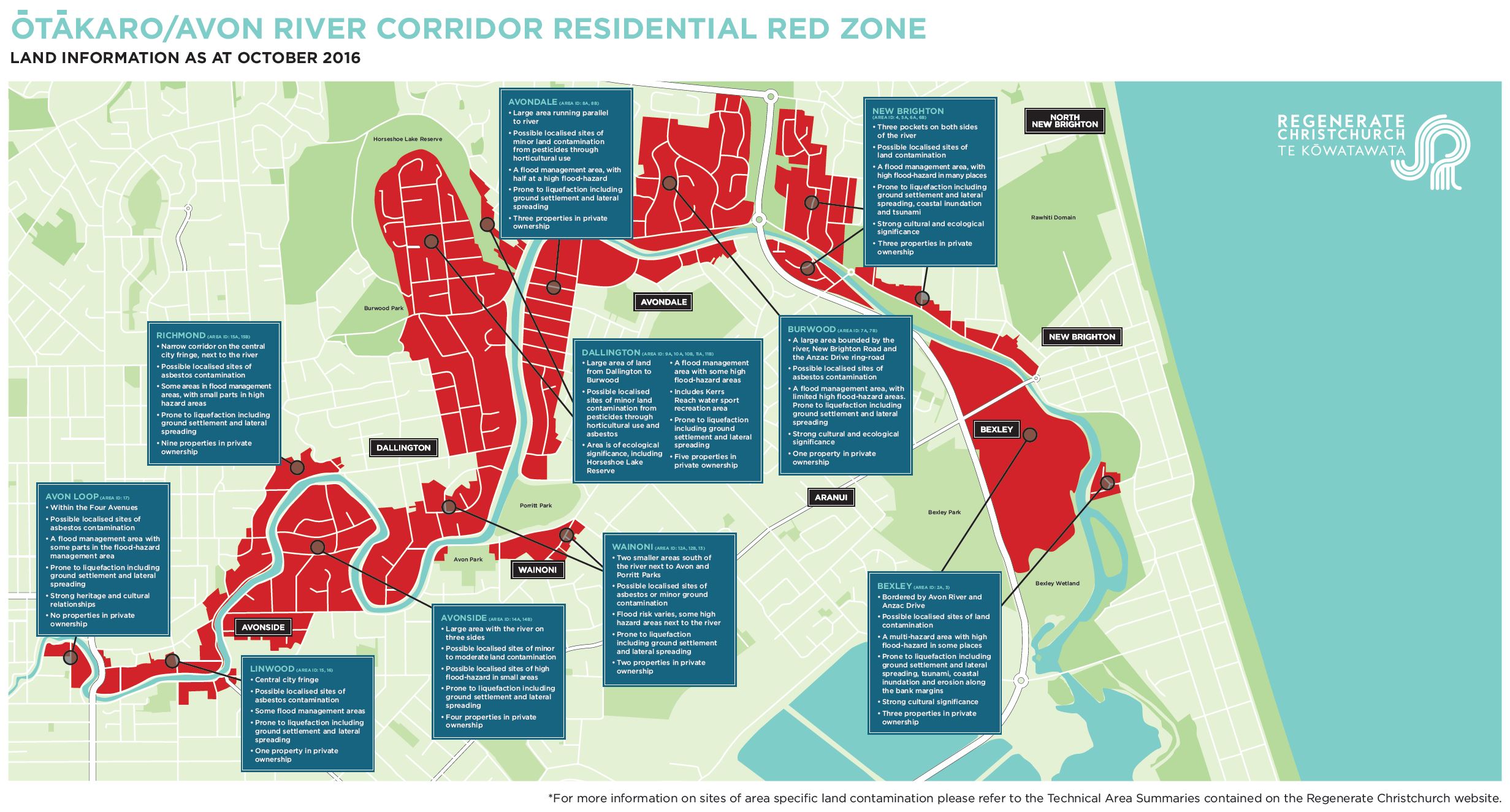
Overview of Residential Red Zone, Natural Environment, Waterways, Groundwater, Coastal Marine Area, Public Facilities, Reserves, Mana Whenua/Ngāi Tahu Interests, Archaeology and Heritage, Special or Other Features, Coastal Hazards, Flooding, Geotechnical, Contamination, Wastewater, Water Supply, Stormwater Management, and Transport.
Southshore – Area ID:1
New Brighton (Admirals Way and Evans Avenue) – Area ID:2
Bexley – Area ID:3
New Brighton (New Brighton Road) – Area ID: 4
Avondale (east of Anzac Drive) – Area ID: 5A
New Brighton (west) – Area ID: 6A, 6B
Burwood – Area ID: 7A, 7B
Avondale – Area ID: 8
Burwood (east of Horseshoe Lake) – Area ID: 9A
Burwood (Horseshoe Lake) – Area ID: 10A, 10B
Dallington (north of McBratneys Road) – Area ID: 11A, 11B
Dallington (south of McBratneys Road) – Area ID: 12
Wainoni – Area ID: 13
Avonside – Area ID:14
Richmond – Area ID: 15
Linwood – Area ID: 16
Avon Loop – Area ID: 17
Brooklands – Area ID: 18
Ōtākaro Avon River corridor, Brooklands and Southshore residential red zones map

Regenerate Christchurch – Flooding
https://engage.regeneratechristchurch.nz/flooding/documents
District Plan floor level information
Coastal hazards information
New Zealand Coastal Society
Flooding hazard provisions and mapping
Historic ‘Black Maps’ of Christchurch showing waterways and swamps: Southshore
Historic ‘Black Maps’ of Christchurch showing waterways and swamps: Avonside
Historic ‘Black Maps’ of Christchurch showing waterways and swamps: Brooklands
Historic ‘Black Maps’ of Christchurch showing waterways and swamps: Lower Avon

Red Zone Futures: Heritage Dr Christine Whybrew from Heritage New Zealand

https://www.redzonefutures.nz/
Public Exhibition
Date: Saturday 26 May – Saturday 30 June 2018
Location: 99 Cashel St, Cashel Mall, Christchurch Central
Online Exhibition: https://engage.regeneratechristchurch.nz/red-zone-futures-exhibition-online
Feedback: https://pacific.surveys.nielsen.com/survey/selfserve/53b/onl45959#?

Heritage – Dr Christine Whybrew from Heritage New Zealand
https://engage.regeneratechristchurch.nz/what-needs-does-christchurch-have-that-could-be-met-by-the-otakaro-avon-river-corridor/videos/3540

We ask Dr Christine Whybrew from Heritage New Zealand why we should think about the Ōtākaro/Avon River corridor’s heritage as we plan for the future? She also shares some of Avonside’s history and discusses how our knowledge of an area’s heritage could help shape plans for its future use.
April 12, 2017

– The river is integral to the history of this area.
– Early farms, homesteads, but not many people are aware of the industrial history of this area.
– Our knowledge of the Red Zones history can affect our future use of these areas.
– At Heritage NZ we oversee the archaeological process and that requires that sites pre 1900 occupation are considered archaeological sites.
– When earthworks are undertaken at these sites, permission is first required from Heritage NZ, often an archaeologist is required to monitor works at the site, record what is on the land and the history of what is associated with what is on the land as well.
– Now our challenge is to use that knowledge, we know more, how can we help use this knowledge for planning in the future?
– Can this history inspire and influence the future uses of this land?
– While we at Heritage NZ know a lot about the Red Zones history, the communities that lived here know a lot lot more.
– We need to think about what technologies are available for us to record these histories and to keep retelling them into the future.
– We also need to think about how to anchor those stories to the place.
– In the Red Zone here in Avonside we can see a number of established trees and plantings, these would be connected to people’s home, to businesses, to life in this area. So we probably need to think about how we are going to protect these trees and plantings into the future to ensure the stories remain connected to the place, and then the people remain connected to the place.

Red Zone Futures: The Story Of Our River

The Story of Our River – He Kōrero Mō Te Awa
https://aureconspatial.maps.arcgis.com/apps/Cascade/index.html?appid=d1d81fc6951d468ab510d46bcad04554

As we plan the future, it’s worth reflecting on the role the Ōtākaro Avon River has played throughout the years.

Ōtākaro means ‘a place of play’. It was named after the Māori children who often played on the banks of the river during times of food gathering (mahinga kai).

“A river of water clearer than crystal.”
John Deans, a settler at Riccarton Bush, describing the Ōtākaro Avon River in 1844.

Mana Whenua – He Kōrero Tuku Iho
As a significant site of settlement and mahinga kai, the Ōtākaro Avon River is of immense cultural importance to Ngāi Tūāhuriri/Ngāi Tahu.
Ngāi Tahu – and Ngāti Māmoe and Waitaha before them – had many permanent and temporary settlement sites of kāinga and pā in the Ōtautahi (Christchurch) area. From these settlements, they gathered natural resources from the surrounding wetlands, rivers, hills, forests, estuaries and coastlines.
The entire landscape was filled with names and stories, which mapped the terrain and narrated its harvest.

Recreational Uses
Pleasure boating and gardens
– In the 19th and early 20th centuries the Ōtākaro Avon River was commonly used for recreation and pleasure boating. There were several privately-run pleasure gardens that offered a variety of attractions. The most famous of these was established by Professor Bickerton at Wainoni.
Bathing
– In 1877, a deep channel was dredged in the river at Cashel Street to create a public pool. However, the water quality was affected by polluted water from the public hospital and the pool never became popular.
Walking and cycling
– Walking and cycling along the banks of the river were popular leisure pursuits, with easy access from nearby roads.
Fishing
– From the 1860s trout were released into the river. Fishing became a popular pastime, but the trout population eventually dwindled due to a decline in their food source.
Rowing
– Early on, the river was used for rowing competitions and practice. In 1950 the river at Wainoni was diverted to straighten and form Kerrs Reach, to allow for competitive rowing. Rowing became a major sport and pastime, and is still popular today.

Urbanisation
In 1851 Christchurch was founded on the banks of the Ōtākaro Avon River, as it was a good water source and a handy transport route. After being initially named the Shakespeare River by the Canterbury Association, the Deans family called it the Avon and that name was ultimately adopted.

The role of the river changed over time. Its narrow, meandering shape and an increase in silt and weeds made navigation difficult. Over time, land transport became the preferred choice for moving people and goods between the city and sea.The role of the river changed over time. Its narrow, meandering shape and an increase in silt and weeds made navigation difficult. Over time, land transport became the preferred choice for moving people and goods between the city and sea.

Between 1850 and 1900, 144 people drowned in the river. A bylaw enabled bollards and chains to be built along the river’s edge to reduce the number of drownings.

In the 1920s Christchurch tailor, R.B Owen, founded the “River Improvement Fund”. He envisaged a boulevard from the city to New Brighton. While this never eventuated, he did plant 53 lime trees along the bank between Evelyn Cousins Avenue and Medway Street in Richmond. Many still grow there today.

Declining Water Quality
Sewage and stormwater
– By the 1860s, water quality was declining and under threat by a proposal to discharge the city’s wastewater into the river. In 1875, the Christchurch Drainage Board devised a plan to separate the city’s sewage and stormwater systems. While the plan ensured sewage was diverted for treatment, stormwater drained into the city’s rivers and streams. By the 1880s there had been a dramatic drop in deaths from waterborne diseases caused by sewage in waterways, but contaminants still entered the river through stormwater and industrial waste.
Weeds
– Another major challenge was the accumulation of weeds. In 1927, a hydraulic sweeper cleared the weeds along the river. While effective at clearing the riverbed, this also sent a great deal of silt down the river to the estuary.
Contamination
– Today, contamination from stormwater, wastewater overflow and other discharges, continue to contribute to poor water quality.

https://www.redzonefutures.nz/

Red Zone Futures: Ōtākaro Avon River Corridor

https://www.redzonefutures.nz/
Public Exhibition
Date: Saturday 26 May – Saturday 30 June 2018
Location: 99 Cashel St, Cashel Mall, Christchurch Central
Online Exhibition: https://engage.regeneratechristchurch.nz/red-zone-futures-exhibition-online
Feedback: https://pacific.surveys.nielsen.com/survey/selfserve/53b/onl45959#?

Red Zone Futures: Our Six Key Principles
https://aureconspatial.maps.arcgis.com/apps/Cascade/index.html?appid=3e5ef08e65b14d4c8720b0fe1490cbcf
1. Mahinga Kai
Mahinga kai provides a holistic framework for us to understand, enjoy, restore and sustainably manage the river and its natural resources.
Mahinga kai presents a unique opportunity to adopt a holistic management approach to the entire Regeneration Area. Not only would it ensure a sustainable approach is taken, it would offer learning opportunities for visitors and local communities.

2. Water in the Future – Ngā Tikanga Wai ā Muri
The highest priorities for Christchurch residents in Nielsen’s 2017 Community Needs Survey were protecting our drinking water and improving water quality. Similarly, as kaitiaki (guardians) of the Ōtākaro Avon River, it’s vitally important to Ngāi Tūāhuriri / Ngāi Tahu that our water quality is protected and restored.
Stormwater Treatment
The Regeneration Area presents a cost-effective opportunity to retrofit stormwater treatment for a large suburban area of Christchurch.
To treat the 2,500-hectare catchment area of Christchurch city, we need approximately 80 hectares of detention ponds and wetlands for stormwater treatment.
Flooding and Sea Level Rise
Christchurch was built on swamps and dunes around the Ōtākaro Avon and Ōpāwaho Heathcote rivers. Because of the low-lying nature of the land, it’s vital that we plan for sea level rise, floods and stormwater treatment.
Currently, temporary stopbanks extend almost the length of the river through the Regeneration Area. These were deisgned for a 20-year lifespan and will need to be replaced with permanent stopbanks.
We need to plan wisely for future flooding events and sea level rise to ensure we can adapt to the future.
Floodable Landscape
Permanent stopbanks are likely to be set further back from the river than temporary stopbanks. This means their height can be reduced (for the same amount of protection) and they can be built on more stable ground. A wider setback also allows for more natural river edges and wetlands, which provide a buffer against flooding as well as improving the habitat of native species such as īnaka (whitebait) and tuna (eels).

3. Living Laboratory – Hanga Taiao Ora
The Regeneration Area provides a unique opportunity for a ‘living laboratory’ – a place to explore and test ideas, take risks, learn, experiment and research.
What could a living laboratory look like?
1. There could be joint applied science degrees focused on the Ōtākaro Avon River Corridor as part of long-term environmental research projects.
2. Christchurch has an ‘experimental buffer’ in the Regeneration Area to test adaption and transformation opportunities, and respond to predicted changes in sea level.
3. There could be adaptable housing experimentation to explore more sustainable housing options.
4. We have received proposals for cultural sculptural and garden heritage trails. A trail could include stories, showcase communities, explain ecological and environmental initiatives and mahinga kai sites.
5. There could be discovery learning in schools with an interest in nature, land and water, and opportunities for schools to pursue outdoor learning and regeneration projects.

4. Memories – Ngā Maharatanga
Before the earthquakes, many communities called the Regeneration Area home. Some families had lived there for generations, forging strong local bonds and enjoying a high quality of life. Sense of place was strong, and residents drew their identity from their connections to the river, parks, estuary and sea.
Countless memories were made in the schools, parks and homes in the area. While the face of the land has changed immeasurably, these stories will always be treasured.
How can we honour these memories?
– Maintain some original streets and residential plantings.
– Retain landscape elements such as curb cut-downs, street lights and signs.
– Incorporate recycled materials like letterboxes or keys in art.
– Provide opportunities to remember former homeowners’ names in the landscape.
– Investigate repurposing the Medway Street footbridge.
– Establish an information centre or outdoor museum.
– Providing interpretation of pre-European, European and ‘red zoning’ with signs and apps.

5. Strengthening Communities
Regenerating this area offers an incredible opportunity to bring communities together and enhance whānaungatanga, in new places that support increased wellbeing.
Reconnecting river communities
– A City to Sea path with links into nearby communities will create places and opportunities for local communities and visitors to come together.
Reconnecting the edges
– The red zoning process left some abrupt edges to neighbourhoods and interrupted streets. Reconnected edges would help to once again link neighbourhoods with the river and create a safer, more appealing river corridor.
Community spaces
– A range of spaces where communities can meet and gather, each designed with the local community, could be created. These could include dog parks, natural playgrounds, fitness stations, community gardens, amphitheatres or buildings.
Community stewardship
– Communities know their own needs best. A framework for community involvement in the governance and delivery of the Regeneration Plan could be developed. This would help communities identify opportunities, and influence the design and ongoing management to align with community aspirations.

6. Regenerating Nature – He Oranga Taiao Hōu
By understanding the river’s floodplain, habitats, soil types, and the effects of sea level rise, we can work with nature to restore the ecology of the land and water.
Naturalising the edges
– There’s an opportunity to recreate some of the wetlands and river terraces to provide habitats for īnaka (whitebait), tuna (eels) and birds, and act as a buffer to limit storm damage.
Changing salinity
– As sea levels rise we’ll increasingly see plants and open spaces adapt as salinity moves further up-river.
Predator control
– Increased predator control and predator-free sanctuaries have enabled native birds to flourish in New Zealand cities. Low-lying wetlands are challenging to predator-proof, so it might be more practical to establish a control programme. If predator control is successful, the Regeneration Area could create a ‘halo’ effect with native birds spreading into people’s backyards.

Our Objectives
For Christchurch:
– Support safe, strong and healthy communities that are well-connected with each other and with the wider city.
– Provide opportunities for enhanced community participation, recreation and leisure.
– Create a restored native habitat with good quality water so there is an abundant source of mahinga kai, birdlife and native species.
– Create opportunities for sustainable economic activity and connections that enhance our wellbeing and prosperity now and into the future.
For New Zealand:
– Develop the Ōtākaro Avon River Corridor to attract a wide range of domestic and international visitors.
– Establish a world-leading living laboratory, where we learn, experiment and research; testing and creating new ideas and ways of living.
– Demonstrate how to adapt to the challenges and opportunities presented by natural hazards, climate change and a river’s floodplain.