NZ National Anthem: God Defend New Zealand

Teen Kiwi vocal group shares spine-tingling rendition of national anthem

Hi!!! Its been a while but we're working on originals so bear with us ?. With our anthem being in the news recently we'd like everyone to know we're available!!!? ????New Zealand Kiwis Allblacks AllBlacks 1 NEWS 1 NEWS Sport All Blacks Tours Three Stuff Newshub

Posted by Le ART on Sunday, June 24, 2018

Porirua College students Tiresa Foma’i, Rosetta Lopa and Anastasia Sirila show how the New Zealand national anthem should be done.

https://www.facebook.com/Le.ART.NZ/videos/1726501194134150/

A Kiwi female vocal group has released a spine-tingling rendition of the New Zealand national anthem on their Facebook page.

The singing group Le ART consists of three teenage girls – Anastasia Sirila and Tiresa Foma’i, both 16, and Rosetta Lopa, 17 – from Porirua College in the Wellington region.


Red Zone Futures: Visitor Attractions

Regenerate Christchurch – Land Use Assessment Report – Visitor Attractions

Overview
– to create land uses within the Area that encourage and facilitate visitor attractions for the benefit of Christchurch residents and Christchurch’s tourism industry by attracting visitors from outside Christchurch. 

Existing Attractions in Christchurch
– Christchurch Adventure Park
– Christchurch Botanic Gardens
– Christchurch Gondola
– International Antarctic Centre
– Ko Tāne Village at Willowbank
– Orana Wildlife Park
– Transitional Cathedral

Strategic Context
The Greater Christchurch Regeneration Act 2016 establishes Regenerate Christchurch’s purpose to “support a vibrant, thriving Christchurch that has economic, social, and lifestyle opportunities for residents, businesses, visitors, investors and developers”.

Our Shared Ōtākaro Avon River Vision
The river is part of us and we are part of the river.
It is a living part of our city.
A place of history and culture
where people gather, play, and celebrate together.
A place of learning and discovery
where traditional knowledge, science and technology meet.
A place for ideas and innovation
where we create new ways of living and connecting.
OUR VISION IS FOR THE RIVER TO CONNECT US TOGETHER –
with each other, with nature and with new possibilities.

For Christchurch
– Support safe, strong and healthy communities that are well-connected with each other and with the wider city.
– Provide opportunities for enhanced community participation, recreation and leisure.
– Create a restored native habitat with good quality water so there is an abundant source of mahinga kai, birdlife and native species.
– Create opportunities for sustainable economic activity and connections that enhance our wellbeing and prosperity now and into the future.
For New Zealand
– Develop the Ōtākaro Avon River Corridor Regeneration Area as a destination that attracts a wide range of domestic and international visitors.
– Establish a world-leading living laboratory, where we learn, experiment and research; testing and creating new ideas and ways of living.
– Demonstrate how to adapt to the challenges and opportunities presented by natural hazards, climate change and a river’s floodplain.

Investment Drivers
1. Christchurch lacks attractions that operate through the shoulder and winter seasons. Also, there are few attractions with flexible and/or late night opening hours.
2. Christchurch falls behind other NZ cities in benefitting from tourism due to reduced visitation and length of stay.
3. A lack of activities in east Christchurch for visiting family and friends of residents has resulted in less visitation from other parts of Christchurch and Canterbury.

Benefits
– Attractions bring people back into east Christchurch and help create linkages between surrounding neighbourhoods and communities.
– Christchurch is known as a desirable city for local, national and international visitors.
– There are local economic growth and employment opportunities.
– The attraction contributes to the regeneration of the Area.

Risks
– The proposed attractions do not generate increased visitation to Christchurch and/or the regeneration of Christchurch.
– The proposed attractions do not align with the Christchurch visitor strategy or the design plan for the Area.
– The attraction becomes an island in east Christchurch and is not integrated into the community or creates gentrification or displacement in east Christchurch.
– No developers or operators can be found for the proposed attractions.

Potential Options
The options are intended to provide context to the development of a long list of land use options only, and should not be interpreted as attractions to be included in the Area.
– Themed Space: represents Christchurch’s history or culture, eg. a maze which incorporates aspects of Christchurch’s cultural heritage, earthquake events and natural environment through sculptures, murals etc.
– Playground: The Margaret Mahy Family Playground has been a huge success and there may be an opportunity to create another playground with a similar theme for east Christchurch residents. This could begin a theme for Christchurch as a playground capital.
– Observatory/Dark Skypark: Use the absence of light pollution in the Area to build an observatory and supporting infrastructure. The observatory at the Arts Centre was popular among locals and also offered a place for educational research.
The Townsend Observatory in the Arts Centre was badly damaged during the 2011 earthquakes. The historic Townsend telescope could be recommissioned in the Area subject to discussions with the Christchurch Arts Centre.
The Area could feature an observatory that catered for visitors and complemented the Mt John Observatory in Tekapo.
Likewise, a Dark Sky approach to the area could build on New Zealand’s reputation for low light pollution.
– Eco-attractions: Create an eco-attraction, to build on Christchurch’s international reputation as a garden city. Christchurch holds a number of botanical and garden events each year.
– Cultural Experience: Create a cultural experience that reflects the history of Christchurch and/or New Zealand. Christchurch currently lacks the type of major cultural experience which is present in other major centres.
The Area offers an opportunity to tell Christchurch’s story and incorporate the Ōtākaro Avon River, which is an important part of Christchurch’s history.
The Tamaki Village, Rotorua, is an interactive Māori cultural experience in Rotorua that gives visitors aview into Māori history,art forms, rituals and traditions.
– Golf Course: New Zealand is known as a golf mecca and Clearwater has been a major success in Christchurch from both an attraction and real estate perspective.
An additional premium course would be preferable as Christchurch does not have a shortage of green fee or standard club courses.
– Theme Park: Create a theme park-based attraction. Rainbow’s End is currently the only major theme park in New Zealand and there is an opportunity to investigate whether there is demand for another theme park attraction.
– Action Sports Facility/Grounds: Construct a sports facility that would attract spectators and/or competitorsin addition to participants. Christchurch is well known as a destination for a range of sports and attracts visitors and competitors both nationally and internationally.
There is an opportunity to further investigate the feasibility of alternative use sporting facilities/grounds in the Area.
– Flatwater Facility: A flatwater facility could provide a base for a number of water sports that attract national and international spectators and add to Christchurch’s current sport facility portfolio.
– Festival Water Sports Course: A festival-style short water sports course for events and competitions between Fitzgerald Avenue and Stanmore Road and linking further downstream that attracts small and unique events for a wide range of water sports.
– Whitewater Sports Hub: Construct a whitewater sports hub that could be used as an attraction as well as for sporting events and education, eg a surf park, white water park, wakeboard park etc. An action water sports facility could provide a base for a number of water sports that attract national and international spectators and add to Christchurch’s current sport facility portfolio.
– Gondola: Construct a gondola that provides a transportation option between the central city and New Brighton. It would have a number of stops along the routes to allow access to different parts of the Corridor and to provide a car-free transport option.
– Art/Sculpture Park: Develop an art/sculpture park that uses the landscape of the Area to display different pieces of outdoor art. Complementary to many other ideas for the Area.
– Eco-sanctuary: Develop an eco-sanctuary for Christchurch to build on the success of existing eco-sanctuaries in Dunedin, Wellington and across New Zealand.
It could be developed to encourage both ecological restoration and education while incorporating other visitor attraction ideas to enhance the offering.
The eco-sanctuary could also be focused around certain themes, eg a butterfly habitat.

“It is recommended that the ability to allow for a wide range of attraction ideas that have the potential to succeed in the Area is included in the long list of land use options.
It is clear that the success of attractions in the Area would be closely linked to the successful regeneration of the Area overall and the creation of a unique and attractive place with appropriate supporting infrastructure that provides investors with the confidence to investigate opportunities in detail.
In particular, the following key points should be considered in any decision around including attractions in the Area:
– Any opportunities presented for attractions need to ensure alignment with the investment objectives and critical success factors established in this report.
– There needs to be a balance of attractions that cater for local residents and international visitors.
– Given the need for greater focus on Christchurch’s tourism sector, priority should be given to assessing and progressing any visitor attraction opportunities that are presented if visitor attraction areas are included in the Plan.
– If visitor attraction areas are included in the long list of land use options, there needs to be a focus on creating “clusters” that are supported by an effective and efficient multi-modal transport network connecting the central city and New Brighton.”

Red Zones Future: Ideas Map by Joanna Gould

Today I created a new Google My Maps, for my Red Zone Futures: Ōtākaro Avon River Corridor ideas/feedback.

My Maps has allowed me to present an interactive map of the whole area showing:

“Rise Up Richmond” Places (black/white icon):
Kai Town, Sutton’s Place, Avebury House, Richmond Community Garden, Richmond Village Green, Richmond Playground, Richmond Neighbourhood Cottage, Ōtākaro Avon River Corridor, Avon-Ōtākaro Cycle Route, Shirley Community Centre, Dudley Creek.

Metro Info Bus Routes (colour coded as per network map).

My ideas for Richmond/Avonside and the Red Zone Futures: Ōtākaro Avon River Corridor  include:
Shirley Community Centre
Dudley Creek
Kai Town
Street Art
Sutton’s Place
River Road Park
River Bank Centre
Retreat Road Park
Kerrs Reach
Woodham Park.

Each pin is clickable and has more info/links, + & -, are in the bottom left hand corner, so you can zoom in/out.

Click on the square with arrow, in the top left hand corner, to show/hide map legend/layers.

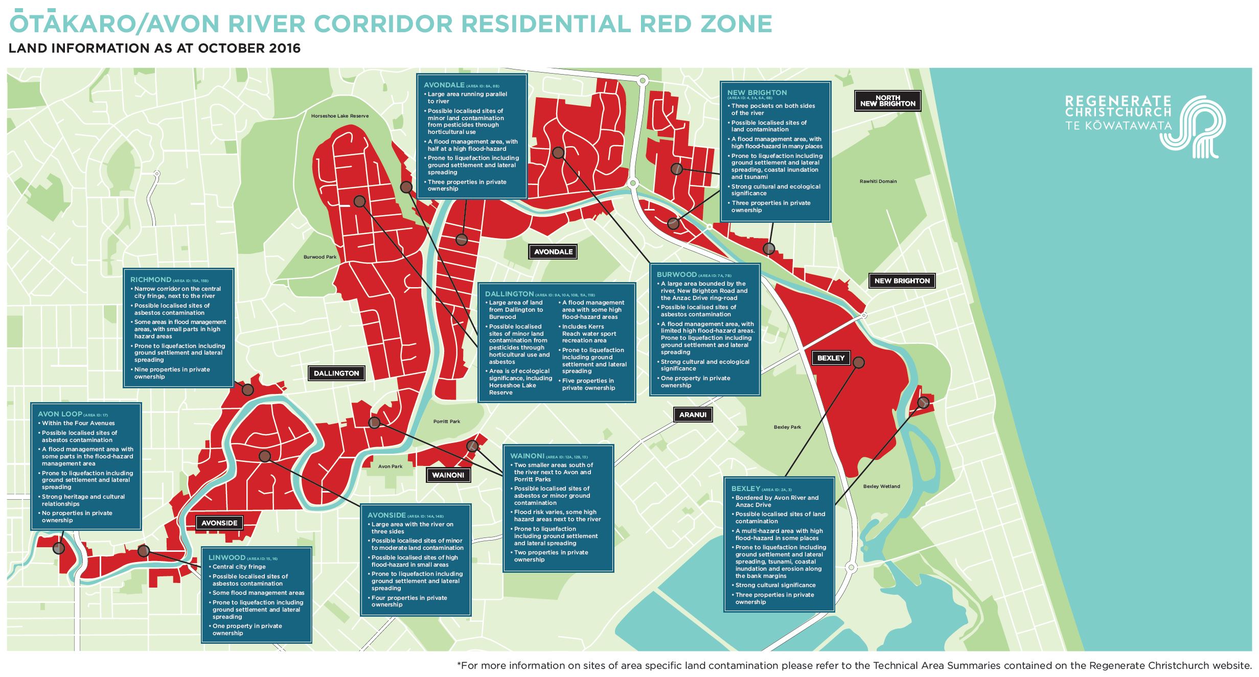
As a Richmond resident, I have seen & heard of the impact that a ‘big project’ like Dudley Creek Flood Remediation, has had on our community.

The lessons we have learnt as a community are that a ‘big project’ can = big overspent budgets, big time delays, big amount of damage to roads used by heavy trucks, big affect on the locals mental health & wellbeing.
Basically a ‘big project’ can cause a community big problems.

I hope Regenerate Christchurch, the Christchurch City Council, and our NZ Government, think through all the land use suggestions for the Red Zone Futures, very carefully. The people in the east of Christchurch have been through enough.

My ideas are based on:
– turning a problem into an opportunity eg. Dudley Creek Trail, an educational & technical learning site on flood remediation.
– marketing what we already have in our local community eg. Avebury House, Richmond Community Garden, Kai Town & Sutton’s Place.
– recycle/reuse infrastructure/buildings that we already have in our local community eg. using part of River Road & Avonside Drive as a multi use pathway, creating a ‘Research, Design & Technology’ River Bank Centre at Avonside Girls & recommission Townsend Observatory from The Arts Centre.
– limiting earthworks, by building attractions on top of the land eg. Retreat Road Park, so we don’t disturb any archaeological/Māori/early settler or contaminated sites.
– combine resources/technology, a hub for ‘learning, discover, ideas and innovation’ eg. creating a ‘Research, Design & Technology’ River Bank Centre at Avonside Girls, and creating Digital Story Telling using Technology.
– bring our unique NZ history to life eg. Māori Heritage Park, Avebury House, Sutton’s Place, R. B. Owen Lime Trees, Kerrs Reach, Woodham Park.
– sharing our Christchurch Earthquakes story eg. Medway Street Bridge Memorial, “wayfinding” info signage, park benches with a plaque of the residential Red Zone street names, picket fence paling with street number/QR Code linked to Google Street View/pre earthquake photos, so you can see the homes that use to be in the residential Red Zone.
– creating unique Visitor Attractions for the benefit of Christchurch residents and visitors from outside Christchurch, plenty of opportunties to take selfies/photos to post on social media and share with family & friends all around the world.

Our Shared Ōtākaro Avon River Vision
The river is part of us and we are part of the river.
It is a living part of our city.
A place of history and culture
where people gather, play, and celebrate together.
A place of learning and discovery
where traditional knowledge, science and technology meet.
A place for ideas and innovation
where we create new ways of living and connecting.

OUR VISION IS FOR THE RIVER TO CONNECT US TOGETHER –
with each other, with nature and with new possibilities.
– Regenerate Christchurch

Red Zone Futures: Cultural, Archaeology and Heritage

Mana Whenua / Ngāi Tahu Cultural History
“Ōtautahi | Christchurch lies within the Takiwā of Ngāi Tūāhuriri who exercise Rangatiratanga and Kaitiakitanga over the wider Christchurch area.
Ōtautahi is of high significance to Ngāi Tūāhuriri and also Ngāi Tahu whānui due to historical occupation, use of natural resources and numerous occupations to sites of significance.
Traditionally Ōtautahi was used for Mahinga Kai, trade, occupation and transport. The historical and current values within the residential red zone and wider areas are based predominantly on Mahinga Kai, Wāhi Taonga and Wāhi Tapu.”

Archaeology and Heritage
The Replacement Christchurch District Plan identifies historic heritage places and settings which represent cultural and historic themes and activities of importance to the district. Significant historic heritage places with a high degree of authenticity and integrity are listed on a schedule and are subject to rules or provisions that protect them from inappropriate subdivision, use and development.
Archsite is the national inventory of archaeological sites for New Zealand. It incorporates information from the New Zealand Archaeological Association’s Site Recording Scheme. This is a “live” inventory that up-dates as new data is fed in from archaeologists working in the field. The data includes archaeological sites, known archaeological areas and indicative archaeological areas.”
https://engage.regeneratechristchurch.nz/cultural-archaeology-and-heritage

For more detailed information for eight areas below, see the Initial Heritage Assessments prepared by Heritage New Zealand Pouhere Taonga.
Initial heritage assessment for Wainoni, Avondale and Bexley residential red zones
Initial heritage assessment for Southshore residential red zone
Initial Heritage Assessment for Richmond residential red zone
Initial Heritage Assessment for New Brighton residential red zone
Initial Heritage Assessment for Brooklands residential red zone
Initial Heritage Assessment for Dallington and Horseshoe Lake residential red zone
Initial Heritage Assessment for Avonside residential red zone
Initial Heritage Assessment for Avon Loop residential red zone

Red Zone Futures: Land Maps and Information

Canterbury Maps
https://canterburymaps.govt.nz/ (scroll to bottom of screen or click ‘Explore’ menu, top right hand corner)
Categories Include:
– Council Services, Environment, History & Cemeteries, Imagery & LiDAR, Marine, Natural Hazards & Civil Defence, Plans & Consents, Property & Land, Recreation & Attractions, Transport & Navigation, Water, Zoning & Boundaries.

Canterbury Maps – Canterbury Historic Aerial Imagery
https://apps.canterburymaps.govt.nz/CanterburyHistoricAerialImagery/ (view on Desktop)
Maps Include:
– 1925 to 1929, 1940 to 1944, 1945 to 1949, 1955 to 1959, 1960 to 1964, 1965 to 1969, 1970 to 1974, 1975 to 1979, 1980 to 1984, 1985 to 1989, 1990 to 1994, 1995 to 1999, 2000 to 2004, 2004 to 2010, Latest Aerial Imagery

Regenerate Christchurch – Land Information
https://engage.regeneratechristchurch.nz/information-about-the-land/documents
Each document includes:
Overview of Residential Red Zone, Natural Environment, Waterways, Groundwater, Coastal Marine Area, Public Facilities, Reserves, Mana Whenua/Ngāi Tahu Interests, Archaeology and Heritage, Special or Other Features, Coastal Hazards, Flooding, Geotechnical, Contamination, Wastewater, Water Supply, Stormwater Management, and Transport.
Southshore – Area ID:1
New Brighton (Admirals Way and Evans Avenue) – Area ID:2
Bexley – Area ID:3
New Brighton (New Brighton Road) – Area ID: 4
Avondale (east of Anzac Drive) – Area ID: 5A
New Brighton (west) – Area ID: 6A, 6B
Burwood – Area ID: 7A, 7B
Avondale – Area ID: 8
Burwood (east of Horseshoe Lake) – Area ID: 9A
Burwood (Horseshoe Lake) – Area ID: 10A, 10B
Dallington (north of McBratneys Road) – Area ID: 11A, 11B
Dallington (south of McBratneys Road) – Area ID: 12
Wainoni – Area ID: 13
Avonside – Area ID:14
Richmond – Area ID: 15
Linwood – Area ID: 16
Avon Loop – Area ID: 17
Brooklands – Area ID: 18
Ōtākaro Avon River corridor, Brooklands and Southshore residential red zones map

Regenerate Christchurch – Flooding
https://engage.regeneratechristchurch.nz/flooding/documents
District Plan floor level information
Coastal hazards information
New Zealand Coastal Society
Flooding hazard provisions and mapping
Historic ‘Black Maps’ of Christchurch showing waterways and swamps: Southshore
Historic ‘Black Maps’ of Christchurch showing waterways and swamps: Avonside
Historic ‘Black Maps’ of Christchurch showing waterways and swamps: Brooklands
Historic ‘Black Maps’ of Christchurch showing waterways and swamps: Lower Avon